A Glacier Fell a Kilometre in Nepal. Where the Water Came From Is Still Unexplained
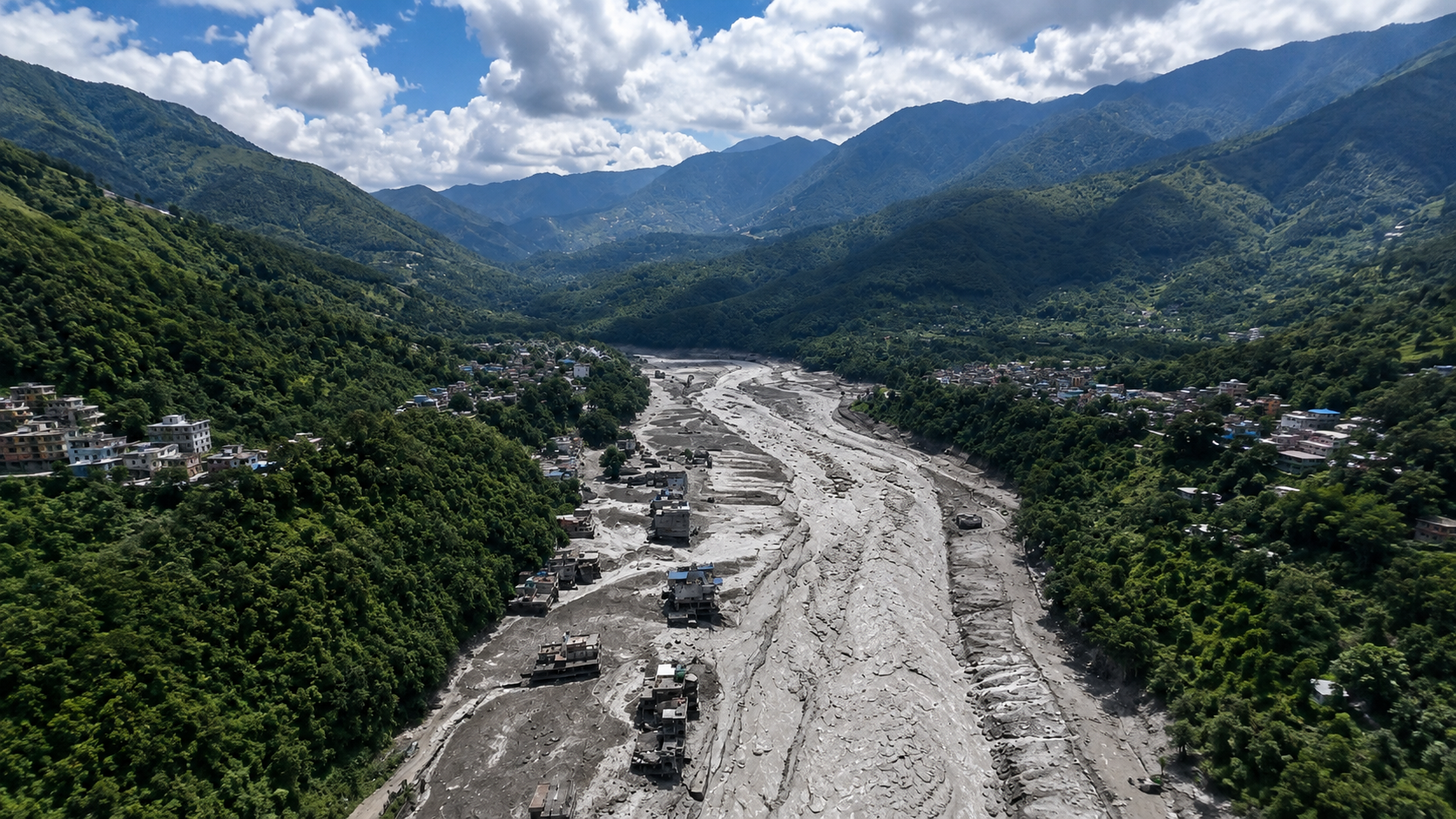
Illustration by Domi Verse X
Solid ice fell more than a kilometre. What reached the villages was a flood.
This article contains affiliate links. If you buy through them, we may earn a small commission at no extra cost to you.
It was a Wednesday morning, a little before nine. The Lhende Khola is a small river that comes down out of the mountains on the Nepal and China border and joins the Bhote Koshi, which then runs south towards Kathmandu. Rasuwa district, where this happens, is home to roughly fifty thousand people. There are farms on the slopes, a border crossing, hydropower plants along the water, and a road that pilgrims and trekkers, many of them with collapsible walking poles strapped to their packs, use to reach Tibet.
Then the river stopped being a river.
What came down the valley was not water in the way you normally picture a flood. It was a moving mass of water, mud, rock and debris, thick enough that survivors described it as more like wet concrete than a wave. Reuters reported that it swept away entire villages and damaged roads, bridges and power plants. One measurement gives a sense of the speed: the International Centre for Integrated Mountain Development reported that at Galchhi, downstream on the Trishuli, water levels rose by as much as nine metres within 30 minutes. That is a three storey building, appearing in the time it takes to drink a coffee.
Almost nobody got a warning.
What the instruments said first
Seismometers across the region picked up a jolt that morning. The United States Geological Survey logged it as a magnitude 4.4 earthquake near the Nepal and Tibet border.
Nepal's own foreign minister, Shisir Khanal, told reporters the flood had started with an earthquake. Newsrooms around the world repeated it. It sounded reasonable. Nepal sits on one of the most seismically active borders on Earth, and earthquakes do trigger landslides.
Then the USGS took a second look, and changed its mind.
Longer period seismic waves, the slow rolling part of the signal, do not look the same for an earthquake as they do for something heavy sliding down a mountain. The revised reading was blunt: the seismic energy had been generated by a landslide, not a tectonic event. And the collapse was so large that it registered at magnitude 5.2, stronger than the earthquake it had been mistaken for.
Read that again, because it is the strangest sentence in this whole story. Something fell off a mountain hard enough that the ground shook like a moderate earthquake, and the instruments could not immediately tell the difference.
Where it actually began
Satellite images pinned down the spot. Dan Shugar, a geoscientist at the University of Calgary, told Reuters that the lower part of a glacier broke off at about five thousand two hundred metres and crashed onto the valley floor roughly 1,200 metres below.
The detail that unsettled him was the shape of the break. He said the line where it snapped off looks almost perfectly straight, as though it had been cut. Glaciers usually crumble. This one parted. From the valley floor, that line would be hard to pick out at all without a compact pair of binoculars, which is part of why satellites did the work here rather than people on the ground.
Five thousand two hundred metres is roughly six times the height of the tallest building in the world. The ice did not slide. It fell.
It is worth pausing on what that altitude means. At five thousand metres the air holds roughly half the oxygen it does at sea level, water left standing freezes overnight, and anything you want to drink warm has to come out of an insulated bottle you filled hours earlier. Nobody lives up there.
That matters, because it is part of why this kind of event is so hard to see coming. The failure happens in a place where there is usually no one watching and no instrument either.
The part that is still unexplained
Here is where the story stops being a normal disaster report.
What fell was ice and rock. Solid. What arrived in the villages, minutes later and many kilometres downstream, was a flood. Somewhere between the cliff and the houses, millions of tonnes of solid material behaved like liquid.
The obvious explanation would be a glacial lake. Meltwater collects behind a natural dam of ice or loose rock, the dam fails, and everything drains at once. It is common enough in the Himalaya to have its own name, a glacial lake outburst flood. It is also close to what happened on this same river system last year, when a glacial lake emptied, killed at least nine people and destroyed the Friendship Bridge linking Nepal and China.
Enjoying this story?
Get a short teaser by email whenever we publish something new. No spam.
That is not what happened this time. Dave Petley, who writes the Landslide Blog for the American Geophysical Union and has spent decades studying failures like this, wrote it plainly: there is no evidence that this was a glacial lake outburst flood. There was no lake to burst.
So where did the water come from?
Petley offers a possible answer and immediately labels it as speculation, which is the honest thing to do three days into an event. He suggests it may be a combination of three things. Some of the ice may have turned into water because of the energy released in the collapse. Some water may already have been locked into the waterlogged monsoon sediment that the mass scooped up on its way down. And some was simply the river that was already there.
The first of those is the one worth sitting with. A falling mass that size does not lose its energy quietly. Friction turns motion into heat, and heat turns ice into water. NASA described the same possible mechanism after a smaller Nepali disaster in 2012, when a rockfall near Annapurna IV dropped more than three thousand metres and triggered a flood on the Seti river: friction in the falling mass, they wrote, may have melted much of the ice.
Researchers have since built physical models of exactly this. Studies of the 2021 Chamoli disaster in India, where about twenty seven million cubic metres of rock and glacier ice came off a mountain face and killed more than two hundred people, found that meltwater generated during the fall was one of the main reasons the debris travelled so far. Around seventeen kilometres, in that case.
If the same thing happened in Nepal, then the mountain did something genuinely strange. It made its own flood on the way down.
That has not been confirmed. An international team has only just started work, and Petley expects it to take weeks or months.
Why this keeps happening here
The uncomfortable background is that these events are becoming more familiar.
The 2021 Chamoli collapse. A glacier above the Swiss village of Blatten in 2025. This one. Different mountains, same shape of event: high, steep ice that lets go without much warning.
These are also working landscapes. The valleys below them are walked daily by guides, porters, pilgrims and trekkers carrying not much more than a headlamp, water and food.
Footwear is the other constant on those routes. Wet ground and long descents are what wear people down, which is why merino wool socks appear on almost every Himalaya packing list.
Scientists are careful about the causes here, and so should we be. Steep glaciers can fail for reasons that have nothing to do with a warming climate. Shugar makes that point himself. But he also notes that the rising frequency of this kind of disaster points to warming as a contributing factor. Meltwater can seep into cracks in ice and rock and weaken them from inside. Permafrost, the frozen ground that acts like glue holding steep slopes together, thaws as temperatures rise, and what it was holding together comes loose.
There is also a human decision layered on top. Petley has made the point repeatedly: large hydropower projects keep being built in valleys that these flows run down, and they keep being destroyed. At least two were damaged or lost this time.
What is known and what is not
As of 27 August 2026, the numbers were still moving and the sources did not agree. Nepal's disaster authority reported 165 dead and 826 missing on the Nepali side. Other outlets reported at least 175 dead, and total missing figures ranging from about 1,300 to 1,500 across both sides of the border, including several hundred foreign trekkers and pilgrims. Those figures will have changed by the time you read this, and probably not for the better.
The cause is settled. A glacier came off a cliff at about five thousand two hundred metres and hit the valley floor a kilometre below.
The mechanism is not. How that became a wall of water fast enough to outrun any warning is a question a team of scientists is only beginning to answer, and the answer may reshape how these valleys are assessed for risk. If you want the longer context for why so many people live and travel in a place that does this, Ed Douglas's Himalaya: A Human History is the most readable account of how these mountains came to be inhabited at all.
The mountains are still there. So are the villages downstream.
Sources
- U.S. Geological Survey, event us7000tbwb, Nepal and Tibet border, 26 August 2026
- Dave Petley, The 26 August 2026 catastrophic debris flow in Nepal and Tibet, The Landslide Blog, Eos, American Geophysical Union
- Reuters, Glacier collapse may have triggered deadly Nepal flash flood, experts say, quoting Dan Shugar, University of Calgary
- EarthSky, Nepal flash flood nightmare: What caused it?, 26 August 2026
- The Conversation, Tsunami of dirt: what caused Nepal's deadly glacial flood?
- Shugar et al., A massive rock and ice avalanche caused the 2021 disaster at Chamoli, Indian Himalaya, Science
- NASA Earth Observatory, Aftermath of the Seti River Landslide, Nepal, May 2012